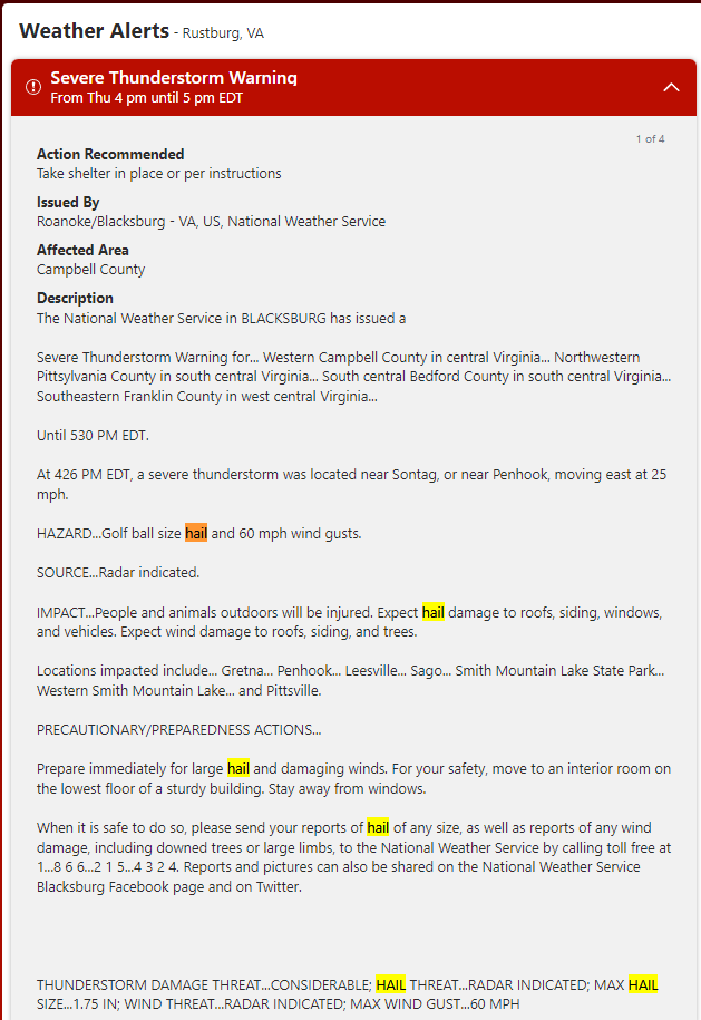
Fire Blight Warning for Central Virginia: Severe Thunderstorms With Hail & Gusts Possible 6 April (Rustburg VA)
TO ALL SOUTH CENTRAL VA POME FRUIT GROWING AREAS: There is a significant risk that today’s thunderstorm(s) will bring hail and 60 mph gusts at locations listed below. If in your or in neighboring orchard there was a recent history of fire blight be ready to apply streptomycin up to 24h after the storm starts to prevent trauma blight. Fire blight primary inoculum is readily available either from overwintered rootstock blight or any cankers carried over from last year. Since it is possible it will vary highly from location to location wait to see if hail or gusts actually affect your location and then decide on applying this spray. Any physical damage to the plant can open wounds that can be entry points for fire blight bacterium. Even if you do not get hail and winds are violent, there is a chance fire blight can reach your orchard from a relatively distant location. If you used captan recently, DO NOT add Regulaid or LI700 to streptomycin for this emergency spray. In you did no use captan recently add Regulaid or LI700 to streptomycin for this emergency spray. Bare in mind that hail can damage not only fruit but branches and trunk, opening wounds that can be infected with fire blight (trauma blight). If you had a history of fire blight and storm does occur on your location, this spray is essential. For other locations that had no fire blight history, bear in mind that 60 mph gusts can carry fire blight inoculum from relatively distant locations to (your) location that had no fire blight in the (recent) past. Hence, if violent storm described below happens and catches your orchard, make sure you spray apply streptomycin. The complete warning is pasted below and screen shot is inserted.
Action Recommended
Issued By
Affected Area
Description